Skydio Flight School: Advanced Bridge Inspection Workflows Using Skydio Drones
expand_more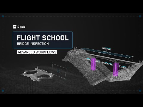
1K subscribers
Drones have become essential tools for bridge inspectors to save costs and improve overall efficiency and safety of critical infrastructure upkeep.
0:00 Introduction
1:30 Planning Your Mission
4:22 Pre-Flight Inspection
5:00 3D Scan
8:23 Manual Inspection
9:44 Map Capture
10:38 Upward Capture
11:25 Post-Flight Processing
12:45 Conclusion
Welcome to Flight School
A video series brought to you by Skydio’s team of in-house experts to help you maximize the output of your Skydio drone program.
This episode features Nicole Bonk and Dave Buhrman, helping you learn the ins and outs of bridge inspection with Skydio.
About drones for bridge inspection:
Drone inspections are revolutionizing infrastructure management by providing a more efficient, cost-effective, and a safer way to inspect critical infrastructure. Traditional inspections often require shutting down roads, bridges, or other infrastructure for extended periods, which can cause significant disruptions and traffic delays. In contrast, drones can quickly and easily access hard-to-reach areas and provide real-time data without causing major disruptions.
Using drones for inspections can also significantly reduce costs associated with infrastructure maintenance. Drones are much cheaper than traditional inspection methods, such as rappelling, bucket trucks or scaffolding, and can cover more ground in less time. By using drones, infrastructure managers can detect issues early and address them before they become more expensive problems.
Join us on Skydio Academy to get formally trained before a mission at https://www.skydio.com/skydio-academy
More tips, tricks, and tutorials at https://skydio.com/support
Learn more about Skydio and bridge inspection: https://www.skydio.com/bridge-inspection
#bridgeinspection #infrastructureinspection #inspection #droneinspection #drone #skydio
vid:185971
Comments0
unfold_more

64K views 9 hours ago

459K views 1 day ago


6.5M views 2 months ago

235K views 5 months ago

107M views 7 months ago

1.9M views 7 months ago

283 views
7 months ago

178 views
7 months ago

1 views
1 year ago
1 views
1 year ago

1 views
1 year ago

491K views 3 years ago

34M views 3 years ago

5.7M views 3 years ago

107M views 4 years ago

15M views 4 years ago

21M views 5 years ago

9.8M views 8 years ago

43M views 9 years ago

11M views 11 years ago

56M views 11 years ago
keyboard_arrow_left
navigate_next


13K views 10 months ago

775K views 5 years ago

15K views 1 year ago

58K views 4 years ago

8.6K views 1 year ago

207K views 1 year ago

19K views 1 year ago

30K views 8 months ago

11K views 1 year ago

18K views 3 years ago

130K views 6 years ago

6.6K views 7 months ago

133K views 1 year ago

95K views 5 years ago

83K views 3 years ago

24K views 7 years ago

2.3K views 4 months ago

4.7K views 2 years ago